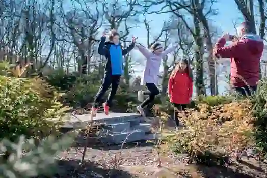
My Ireland


糟糕......没有互联网连接
您在离线时仍可以将项目添加到信息板。新的旅行建议仅在您重新上线后才会显示。
没有实体位置的项目不会显示在地图视图中。
您的信息板似乎是空的


收藏封面图像
共享您信息板的人可以看到


位置权限
- 查看附近的优惠
- 查看与您位置相关的旅行灵感
- 获取当地天气预报和重要信息


隐私
我们非常重视您的隐私,只有在您允许的情况下才会处理您的数据。在可能的情况下,我们会以匿名方式处理您的数据,而且我们存储您的数据绝不会超过必要的时限。如需详细了解我们如何处理您的个人数据,请阅读我们的隐私政策。
重置您的信息板
这将从您的信息板中删除您之前标示为“喜欢”的所有项目。请注意,您不能撤销此操作。
User
位置权限
- 查看附近的优惠
- 查看与您位置相关的旅行灵感
- 获取当地天气预报和重要信息
重置您的信息板
这将从您的信息板中删除您之前标示为“喜欢”的所有项目。请注意,您不能撤销此操作。


Hiking the Mourne Way


Wondering how to take in the majesty of the Mournes in just two days? We’ve got just the route for you…
Traversing the foothills of the Mourne Mountains from Newcastle on the Irish Sea to Rostrevor on Carlingford Lough, the Mourne Way is a fantastic route to follow for a taste of all the Mournes have to offer.


Day 1
A verdant forest park, breathtaking valleys and rugged mountains – the first half of the Mourne Way isn’t short on incredible views.
Newcastle to Spelga Pass
探索第1天Newcastle to Tollymore Forest Park
Tollymore Forest Park, County Down


Set off on your adventure from Newcastle Visitors Centre and head for Tollymore Forest Park. This 630-hectare site sits at the foot of the Mourne Mountains with marked trails taking in woodland, mountain peaks and the Shimna River. It’s a pretty magical place packed with monuments, follies and stone bridges – so magical that it featured as the Haunted Forest in HBO’s hit series Game of Thrones®. Don’t worry though, you’ll find no White Walkers hiking along the trail! But if you want to explore key filming locations from the show while you’re here, then the Tollymore Forest Trek is for you.
As you journey through the forest, you’ll pass Slieve Commedagh and the Spinkwee River which leads to the 10-metre high Cascade Falls. The section ends at a track junction at the bottom of the Spinkwee River.

4公里
Tollymore Forest Park to Happy Valley
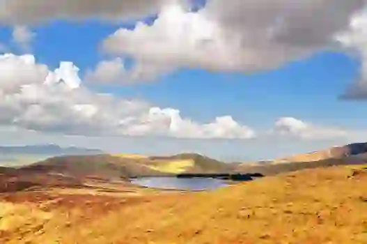
Mourne Mountains, County Down
Optional Description Text


Get set to swap leafy forest trails for the rugged terrain of the Mournes. Hikers leave behind the Spinkwee for the Shimna River, crossed by stepping stones if the water allows safe passage. You can also cross by footbridge, following rapids upstream. The track leads you to the King’s Grave – a 3,000-year-old Bronze Age burial site – and further on to the Trassey Track. As one of the busiest routes in the Mournes, you’re sure to bump into a fellow walker or two. Follow the route south and you’ll emerge to open terrain, taking in the mighty Mournes. Further on, use the stone wall as your guide to reach the Happy Valley, nestled between the foothills of Slieve Meelmore and Slieve Meelbeg.


7公里
Happy Valley to Spelga Pass
Mourne Mountains, County Down
Optional Description Text


This next section leads to Fofanny Reservoir across a metal footbridge, through pine trees and out to the Blue Quarry car park. This is where things get steep! For an easier journey, take the alternative route along the road to reach the pass. If you’re an experienced hiker and the weather is on your side, follow the official route to Spelga Pass. This unmarked climb crosses the 500-metre-high summit of Butter Mountain and the views of the Mournes at the top are breathtaking. The navigational descent follows the ridge along a fence past the summit of Spaltha. Take care as the way down is steep. You'll find a stone wall that guides you back to the road down to the Spelga Pass.


5公里


Day 2
The Mournes many peaks give way to rivers, rolling hills and Kilbroney Forest Park as your epic hiking adventure comes to an end.
Spelga Pass to Kilbroney Forest Park
探索第2天Spelga Pass to Leitrim Lodge
Leitrim Lodge, Mourne Mountains, County Down
Optional Description Text


The adventure continues as you journey through three mountain valleys to Leitrim Lodge. Upland tracks lead to Northern Ireland’s longest river, the River Bann, and past the peaks of Slievenamiskan and Hen Mountain, following on to a mountain track known as the New Bog Road. Get set for a steady climb along the Rocky River valley with lovely views of granite tors – the track leads towards Pigeon Rock Mountain. On your descent you’ll cross the Rocky River only to climb again, heading for the ridge between Rocky Mountain and Tornamrock, over raised boglands and down to the track junction at Leitrim Lodge.


7公里
Leitrim Lodge to Yellow Water Picnic Area
Mourne Mountains, County Down
Optional Description Text


This part of the route trades mountain views for forest trails as you pass the foothills of Altataggart Mountain into a landscape dotted with Scots pine trees onto the lower slopes of Tievedockaragh and downwards over a stile into the grounds of Rostrevor Forest. The rugged terrain of the Mournes blends into rolling countryside before leading into a passage of pine trees and on to the Yellow Water Picnic Area. Take the time to relax, unwind and refuel with some pre-packed snacks here in this tranquil spot.
4公里
Yellow Water Picnic Area to Kilbroney Forest Park
Kilbroney Forest Park, County Down
Optional Description Text


The end is in sight – and what a sight it is! This last portion of the trail follows over the Yellow Water River through pine trees where you will catch glimpses of Kilbroney River valley, the charming town of Rostrevor and the serene backdrop of Carlingford Lough. Follow the signed track onwards on a steady descent through the trees and past the camping grounds where a stone bridge leads through to the main car park for Kilbroney Forest Park – the end of the Mourne Way.